A Look At Montes Apenninus
I finished post-processing the two remaining sets of images from my first telescope observations with my new telescope. For a "first light" observation session with a new telescope... and never having done any astrophotography previously... these images turned out quite well! These two resulting images (each at a super-resolution of 96 megapixels) provide a much closer look at Montes Apenninus... a lunar mountain range named after the Apennine Mountains in Italy.
This rugged lunar mountain range towers to almost 18,000 feet in height. The total length of the mountain range is approximately 370 miles. I point this out because most people assume that the moon is relatively level and dotted with craters simply by its appearance from Earth. The reality is that the moon has a mostly hilly, rolling landscape and, obviously, some areas consist of towering mountain ranges as well. This particular rugged and towering mountain range ends at the crater Eratosthenes...
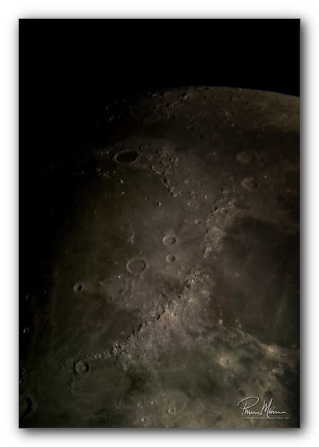
Just beyond the crater Eratosthenes is the more well-known crater, Copernicus (see photo below). Copernicus is the larger crater toward the bottom left of the image. See those three things in the middle of Copernicus that look like boulders? Those are actually three mountains that are 4000 feet tall!
The area around Copernicus is rich in the mineral Olivine which is green hence the greenish hue to this area of the moon which is more noticeable in my photo above. The moon actually does have some subtle color to it and this subtle color varies from site to site depending upon the minerals found in the particular area.

This crater, Copernicus, is 58 miles in diameter. That is approximately 2700 square miles in size. By comparison, the entire New York City Metropolitan area is approximately 3300 square miles. Chicago's Metropolitan area is approximately 2100 square miles. So the size of Copernicus falls right between the size of the two largest cities in the US (the two largest by land area). I suspect this crater is significantly larger than most people realize.
There are far larger craters on the far side of the moon as can be seen in this NASA video, below, compiled from imagery from the Lunar Reconnaissance Orbiter. This mission, LCROSS (Lunar CRater Observing and Sensing Satellite), was a lunar imaging and mapping project that I was fortunate enough to be a small part of by sorting and classifying some of the massive amount of imagery data that was collected by this lunar orbiter. The primary purpose of this mission was to confirm the presence of water in a shadowed crater near the south pole of the moon. The mission was a success (in 2009) by proving the presence of water on the moon and by providing detailed imagery of the entire moon. This detailed imagery allowed a large team of us to completely and accurately map the moon in three dimensions.
Of note pertaining to the Montes Apenninus mountain range, Apollo 15 landed in a valley on the northern end of this mountain range. Apollo 15 was the first long stay on the moon by our astronauts to allow a greater focus on science. This was also the mission that included the Lunar Roving Vehicle. Quite a bit of NASA equipment was left behind after this mission and is visible in NASA's LCROSS imaging.
As you can clearly see in this NASA image, below, the terrain of the moon is rolling. Actually, you can clearly see that the Lunar Landing Module (LLM) is tilted on unlevel ground... Astronaut David Scott had difficulty seeing these relatively shallow and rolling craters as he landed the LLM on the surface of the moon. He inadvertently placed one of the rear footpads on the edge of a 20 foot crater. The footpad was actually dangling in the air near the edge of this small crater!
Anyway, it was really nice and actually quite exciting to do some of my own close-up, super-resolution imaging of this Montes Apennines region of the moon! I hope to get out there again soon to tackle another region of the moon.
This rugged lunar mountain range towers to almost 18,000 feet in height. The total length of the mountain range is approximately 370 miles. I point this out because most people assume that the moon is relatively level and dotted with craters simply by its appearance from Earth. The reality is that the moon has a mostly hilly, rolling landscape and, obviously, some areas consist of towering mountain ranges as well. This particular rugged and towering mountain range ends at the crater Eratosthenes...

Just beyond the crater Eratosthenes is the more well-known crater, Copernicus (see photo below). Copernicus is the larger crater toward the bottom left of the image. See those three things in the middle of Copernicus that look like boulders? Those are actually three mountains that are 4000 feet tall!
The area around Copernicus is rich in the mineral Olivine which is green hence the greenish hue to this area of the moon which is more noticeable in my photo above. The moon actually does have some subtle color to it and this subtle color varies from site to site depending upon the minerals found in the particular area.

This crater, Copernicus, is 58 miles in diameter. That is approximately 2700 square miles in size. By comparison, the entire New York City Metropolitan area is approximately 3300 square miles. Chicago's Metropolitan area is approximately 2100 square miles. So the size of Copernicus falls right between the size of the two largest cities in the US (the two largest by land area). I suspect this crater is significantly larger than most people realize.
There are far larger craters on the far side of the moon as can be seen in this NASA video, below, compiled from imagery from the Lunar Reconnaissance Orbiter. This mission, LCROSS (Lunar CRater Observing and Sensing Satellite), was a lunar imaging and mapping project that I was fortunate enough to be a small part of by sorting and classifying some of the massive amount of imagery data that was collected by this lunar orbiter. The primary purpose of this mission was to confirm the presence of water in a shadowed crater near the south pole of the moon. The mission was a success (in 2009) by proving the presence of water on the moon and by providing detailed imagery of the entire moon. This detailed imagery allowed a large team of us to completely and accurately map the moon in three dimensions.
Of note pertaining to the Montes Apenninus mountain range, Apollo 15 landed in a valley on the northern end of this mountain range. Apollo 15 was the first long stay on the moon by our astronauts to allow a greater focus on science. This was also the mission that included the Lunar Roving Vehicle. Quite a bit of NASA equipment was left behind after this mission and is visible in NASA's LCROSS imaging.
As you can clearly see in this NASA image, below, the terrain of the moon is rolling. Actually, you can clearly see that the Lunar Landing Module (LLM) is tilted on unlevel ground... Astronaut David Scott had difficulty seeing these relatively shallow and rolling craters as he landed the LLM on the surface of the moon. He inadvertently placed one of the rear footpads on the edge of a 20 foot crater. The footpad was actually dangling in the air near the edge of this small crater!
 |
| Image courtesy of NASA |
Anyway, it was really nice and actually quite exciting to do some of my own close-up, super-resolution imaging of this Montes Apennines region of the moon! I hope to get out there again soon to tackle another region of the moon.
Comments
Post a Comment